
|
|
||
|
|||
 |
(40)/TO-Z/VALE-TurSer-40.jpg) |
-55/BOOK-cort-40.jpg) |
|
 |
||
 |
|||
 |
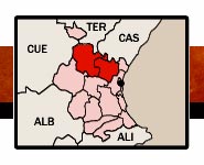
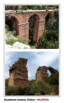
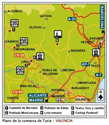
ACUEDUCTO DE PEÑA CORTADA (CHELVA)INFORMACIÓN HISTORICO-ARTÍSTICAEl acueducto mide unos 28,6 kilómetros, la captación se sitúa en el río Tuejar y el destino pudo ser Sagunto; se conservan muchas arcadas por todo el itinerario, son magníficos los puentes de Barranco del Convento (Chelva), de la Rambla de Alcotas (Calles), el Barranco de Cueva del Gato (Calles) y el de Torre de Castro (Calles), aunque existen muchos otros puentes. Cronología romana de fines del siglo I a inicios del siglo II d.C. HORARIOS-ENTRADAAcceso libre, sin entradas, ni horarios. ACCESOEl acueducto de Peña Cortada o de La Serrada, pasa por varios pueblos (Tuejar, Chelva, Calles y Domeño). Para visitar el tramo más interesante se recomienda ir a Chelva, justo a la Plaza de Toros, seguir las indicaciones, dejar el coche en el parking y seguir cualquiera de los 2 caminos pues uno va a la parte superior y el otro a la inferior del acueducto. ACCESO PARA MINUSVÁLIDOSNo factible para sillas de ruedas, el sendero es escarpado con desprendimientos. |
 |
AQUEDUCT OF PEÑA CORTADA (CHELVA)HISTORICAL-ARTISTIC INFORMATIONThe aqueduct measures about 28,6 kilometers (17,73 miles), the catchment is located on the river Tuejar & the destination sems to be Sagunto; Many arcades are conserved throughout the itinerary, the bridges of Barranco del Convento (Chelva), Rambla de Alcotas (Calles), Cueva del Gato (calles) and Torre de Castro (Calles), there are many bridges. Roman chronology from the end of the 1 st century to beginning of the 2 nd century A.D. TICKETS AND TIMETABLEFree access, no tickets, no timetable. LOCATIONThe aqueduct of Peña Cortada or La Serrada, passes through several towns (Tuejar, Chelva, Calles and Domeño). To visit the most interesting section is recommended to go to Chelva, just to the Bullring and follown the signpost, leave the car in a parking area, and follow any of the 2 ways, one gone to the top, the other to the bottom of the aqueduct. ACCESS FOR THE HANDICAPPEDNot feasible for wheelchairs, the way is steep, with landslides. |
||||
|
 |
|
 |
|
||||
|
|
 |
||||||
 |
 |
|||||||||||||||
| VALENCIA I | VALENCIA II | ||||||||||||||
Septiembre de 2017 |
CAMPO DE COFRENTES | REQUENA - UTIEL | |||||||||||||
| LIRIA - LLIRIA | TURIA - SERRANOS | ||||||||||||||
| SAGUNTO | CAÑOLES Y SAFOR | (INFO PRÁCTICA) |
|||||||||||||
| BUÑOL-CHIVA | CULLERA-SUECA | ||||||||||||||
| ALCIRA-L'ALCUDIA | ENGUERA-BOLBAITE | ||||||||||||||
WEB DESARROLLADA POR EXPERTOS EN ARQUEOLOGÍA Y TURISMO - WEB DEVELOPED BY ARCHAEOLOGY & TOURIST EXPERTS |
|||||||||||||||